Goolengook River
The forest contained in the Goolengook Block, south-east of Mount Ellery, is under threat.
An area rated as a Site of National Significance (SOS) for rainforest values is now available for logging. A recent bridge has been built across the Goolengook river, and 5km of roading as well as 6 clearfell coupes are planned within the SOS. Two coupes in the south of the block have already been logged within the SOS.
The new bridge has included a single track that fords the river and a clearing of
rainforest adjacent to the bridge. Nearby is Freddys Creek, which the Management
Plan clearly states as "no roading through reserve" to protect the Slender Tree
Fern that grows along its banks. Where Goolengook Road crosses Freddys Creek,
the culvert is blocked and the creek has flooded almost to road level.
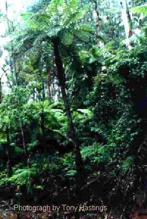
The area is home to Spot-tail Quoll, Long Footed Potoroo, Sooty Owl, Powerful Owl, Yellow-tailed Black Cockatoo, Greater Glider, Yellow-Bellied Glider as well as significant and rare plant species, such as the Slender Tree Fern, Skirted Tree Fern, Oval Fork-Fern and Green Bird-Orchid.
How DCNR justify logging a SOS is explained in a recent harvesting list, from the Cobon Block. Coupe 505/05 is located adjacent to Hensleigh Creek, is next to a DFA coupe, and within a State Site of Significance for rainforest values. A Memorandum a.html"ed to the harvesting list notes "this coupe has a "FFF" functional check approval category of 2 - further functional input required at coupe plan stage". "With the finalization of the FMA plan the proposed RFSOS's are incorporated into the plan zoning scheme where required. As this coupe is in the General Management Zone there is no longer a requirement to consult with FFF staff on this matter"(1).
In that example it is clear that flora and fauna studies were not carried out, despite the obvious value of the area and potential endangered species habitat. The coupes planned in the Goolengook block are in the same situation - they are in the General Management Zone and are mostly unstudied. During the block survey, there was one vegetation quadrat survey conducted on a ridge, and one Herpertofauna Search carried out, also on a ridge(2).
Studies conducted along creeks in the surrounding area found rainforest and significant plants at almost every site, and coupes 515/06 and 515/07 have recognised warm temperate rainforest within their boundaries that is unprotected.
The Proposed Code of Forest Practices states: "Rainforest must be excluded from timber harvesting, and because rainforest communities may be particularly vulnerable to adjacent disturbance they should be surrounded by an appropriate buffer". "For stands containing nationally significant rainforest that is sensitive to management operations - the highest degree of protection, generally sub-catchment level, except where full protection can be provided by other measures"(3).
DCNR has failed to fulfill its code of practice, and it is up to us to protect Goolengook.
Sources:
-
DCNR Memorandum 2/1/96; "File note Coupe 885/505/05"
Map 1 "Sampling Sites" in Lobert, Gillespie et al (1991); "Flora and Fauna of the Goolengook Forest Block" DCE Ecological Survey Report #35
from Section 2.2.7 "Protection of Rainforest in DCNR", 1995; "Proposed Code of Forest Practices for Timber Production"
GreenNet