These are routes designed to be used with a 1:100000 road map of Far East Gippsland, available for purchase from the Department of Sustainability and Environment (DSE) offices, Bonang Store and Orbost Newsagents for approximately $10.00. Distances are approximate, and are not cumulative. Times are also approximate and do not include stops for picnics and viewing the scenery.
Remember to check road conditions and road closures with the DSE before you depart. Most tracks are 4WD after rain, and gates are closed seasonally. There is no petrol for sale at Bendoc. Bonang Store sells unleaded and premium unleaded petrol only, and is open for short periods of time every day except Tuesday.
To download a printable version of this document click on Self Drive Tours.rtf
O kms- Start from the corner of Errinundra Rd and Gap rd (also called Bonang-Bendoc Rd) - Drive along Gap Rd and enjoy the Result Creek catchment.
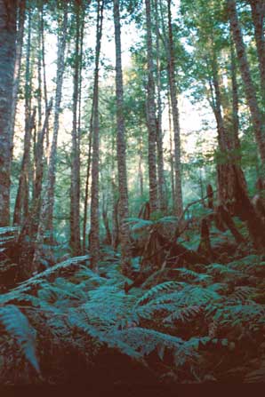
3.5 kms- Result Creek crosses under the road. On the left hand side of the road you can observe the sassafras and tree ferns. The forest on the right hand side of the road is scheduled for logging.
If one feels like a walk in the forest, there is a two and a half hour return walk (medium difficulty) to one of the last giants left, an Errinundra shining gum 17 metres in girth. Access to this walk is on the right hand side of the road just after the creek crosses under the road. Follow the tapes to the tree, GPS is..
500 m- Dead sassafrass, on left hand side of the Gap Rd. An example of dieback of rainforest species through edge effect. In this case the road is letting in sunlight that wouldn't normally be absorbed by the sassafras, causing it to die.
1.4 kms- Turn into Gunmark Rd. The corner of Gunmark and Gap rd is the Bidawal education reserve. This is situated on the left hand side of the road. An area left for the original inhabitants of this area, the Bidwali people.
1.5 kms- Centre Road- Centre Road and Survey Road are two areas that have been controversial with environmentalist and the logging industry for over fifteen years. Both areas have been a focus for direct action for just as many years. There have been questions raised on rainforest and mixed forest logging in these areas. They are also the home of endangered species.
300 m - Survey Road - Shortcut through rainforest and clearfells to Errinundra Rd. See Survey Rd Detour.
1.1kms - Harris Daishowa eucalypt plantation. Plantations have been established on private land bought by Harris Daishowa throughout the area. Harris Daishowa, now owned by Nippon Unipac, is a large exporter of woodchips from East Gippsland and SE NSW. Can you spot the difference between this and the forest regenerated by DSE?
1.1kms - Teatree flat picnic area- This rare alpine wetland is inside the park, yet is drying up due to total catchment logging to the south. Regrowth is sucking up large volumes of water and this swamp has been estimated to dry up around 2003. Pollen studies at this site suggest there has been more disturbance to the vegetation here since clearfelling began 30 years ago, than over the past 12,000 years.
6.4 kms - Thinnings start.
100 m- Corner of Gunmark and Goonmirk Rocks Road. An option for a number of short walks here. If you venture a little way down Goonmirk Rocks Road (the highest point on the plateau) you can do the Rooty Break trail walk, an easy 6 kms loop walk. Take the right hand fork down Coast Range Road until you get to Rooty Break Trail, walk up Rooty Break, a truly magical experience, and then back down Goonmirk Rocks Rd, past Goonmirk Rocks, famous for the three different mountain peppers occuring in the same place. Continue down Goonmirk Rocks Rd to your car. Alternatively you can drive your car to Goonmirk Rocks to the start of Rooty Break Trail.
Another easy but longer walk is approximately 17kms round trip. Drive up Goonmirk Rocks Rd till you get to Aspen Battery Track, walk down Aspen Battery Track through the National Park. Once the National Park stops you will walk through beautiful state forest that is scheduled to be logged. You will also see a historical mine site (picnic tables here). Stay on Aspen Battery Track until it finishes at Clarksville road, (it's signposted), turn right on Clarksville and follow until Goonmirk Rocks Rd, walk up Goonmirk Rocks Rd passing Goonmirk rocks and Rooty Break Trail again on your way back to your car.
[Note: Goonmirk Rocks Road takes you to Bendoc, down Clarksville rd.]
6.4 kms- the corner of Gunmark Rd and Errinundra road (This is 6.4kms from the corner of Gunmark rd and Goonmirk rocks Road)
Turn right to finish Plateau Loop, back where you started, at the corner of the Gap Rd and Errinundra Rd. Find information in Errinundra Road route, and read it backwards for more highlights along the way.
Turn left to join Errinundra Road route.
Start at intersection of Errinundra Road and Greens Rd/Mt Morris. To get to this point, start with Errinundra rd route.
2.3 kms- Ada divide- A short walk down Ada Divide will have you witnessing giant Mountain Ash trees. The right hand side is National Park, the left hand side scheduled to be logged.
500m - Ocean View lookout- this spectacular view point looking south will show you the Goolengook Valley in its entirety.
2 kms - Intersection of Greens rd and B.A road- If you like take a walk down Greens Rd to view a better look at the Goolengook valley and enormous granite boulders. Continue driving down B.A road.
4.3 kms - Corner of Big River and B.A road- Access to Mt Ellery or continue to Goongerah. For information see Ellery Loop tour.
If you go down Survey Rd, you can take a look at some rainforest directly next to clearfell.
(access to Errinundra Road)
300 m-You will see on the left hand side National Park and on the right, a regenerated clearfell. This is not a plantation it is your state forest.
1.4kms- On the right hand side of the road you will see one of the last patches of old growth forest left on the whole road.
1.3kms-You will now start to notice trees cut down and left on the side of the road. This is because forest roads must be kept dry for hauling out logs.
300 m-Another small patch of old growth forest scheduled to be logged on your right. On the left is still National Park. Endangered long footed potoroo found early 2003 in this forest.
1.7kms - Devastation coupe 1
500 m - Devastation coupe 2. Both these coupes were finished in late November 2002. Note how much timber is left on the ground. If not already this will be burnt by petroleum jelly dropped by helicopters. (Don't take any timber as you may get caught and fined)
600 m- The last patch of old growth scheduled to be logged. Critically endangered Spot Tailed Quoll found here December 2000.
500m - Sassafras gully with no buffer, edge effect is obvious and inadequate protection will result in the death of this vegetation.
1.7 kms - Survey road and Errinundra road intersection.
0 km- Start at cnr of Errinundra Rd and Gap Rd. (There is a campground a few metres from here on the right hand side of Gap Rd, just on the Bonang River). Drive down Errinundra Rd. Errinundra Road takes you onto the Errinundra Plateau with spectacular views of the Brodribb River catchment and mountains to the south.
0.8 km - Thinnings across road from National Park
3.3 km - Enter Errinundra National Park. Check out the views.
2.5 kms - Bonang River Camp Ground picnic table and water point on the beautiful Bonang River.
1.5 kms - Survey Road (see Survey Rd Detour for details - remember to read backwards)
2.6 kms - Alstregens Road. This area is scheduled for logging, it is also part of the Cobb Hill National Rainforest Site of Significance. If you are feeling adventurous, take a short walk down into the rainforest gully at the start of Alstregens Road on the right hand side and experience the dark rainforest canopy in the gully. Click here for photo.
1.3 kms - Cnr of Gunmark Rd and Errinundra Rd. Continue on Errinundra Rd to travel across and down the beautiful plateau, or turn left onto Gunmark Rd to take Plateau loop route (remember you are going backwards).
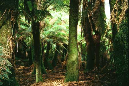
1.9 km - Rainforest Boardwalk on Blockade Track. Turn left onto Blockade Track to the Rainforest Boardwalk. This short walk shows a number of species of vegetation of the Errinundra Plateau. Built thirty years ago after the first Errinundra Plateau protests encouraged the establishment of Errinundra National Park.
300 m - Hammonds Road. Take the time to drive down Hammonds Road to see a good example of Forest Management in the area as well as the spectacular sights of Sassafras Basin. If feeling energetic journey into the rainforest situated at the end of Hammonds Rd (take map and compass).
1.6 km - Brodribb Forest Walk. On right hand side of Errinundra Rd is a small sign directing you to a 1 km walk through beautiful forest under tree ferns which ends with a bang!
2.9 km - Cnr of Errinundra Rd and Greens Rd. Either take the Plateau via Mt Ellery route (eventually back to Bonang Rd) or continue on Errinundra Rd down the Plateau and along the spectacular Errinundra River. But first, here you are at Wooly Butt Hill or Mount Morris. On the right hand side of the road junction is an easy 20 minute walking track through Alpine Ash to a rocky outcrop at the top. Western views of Brodribb wilderness, Mt Kosciusko and Tingaringi.
17.5 km - Errinundra River Swimming Spot, at the corner of Helmers Road. After journeying down the plateau you have reached the warm temperate zone. Ancient Kanukas line the Errinundra River, and on a hot day this location is an ideal spot for dip. If arriving at dinner time, you may catch a glimpse of the platypus that inhabit the area.
1.1 km -Ada River Campground. A beautiful camp spot with fresh drinking water from the Ada river, fireplaces and a toilet.
12.7 km - cnr of Combienbar and Errinundra Rd. After completing your drive down the most beautiful road in the State turn right onto Combinebar Rd and continue following the Errinundra River till it meets the Bemm.
11.1 km - Club Terrace, a small hamlet with a phone. Here you can continue for 5 kms to the Princess Hwy, to Orbost on the left or Cann River to the right. Or you can take the option to turn down Euchre Valley Drive to Goolengook Rd and do the Coast to Mountain route, finally ending in Goongerah, where camping is available.
0 km - Start Bemm River Bridge, Princess Hwy. Stop and look at the spectacular warm temperate rainforest on the Bemm River. On the east side of the Bemm River bridge, turn north off the Princess Hwy into Euchre Valley Drive
4 kms - Cnr of Goolengook Rd and Euchre Valley Drive (Turn right if wanting to access Errinundra Rd route or START HERE if coming from Errinundra Rd drive tour). Drive up Goolengook rd, witnessing clearfell logging and thinnings operations but also experiencing amazing mountain views as this road climbs up Mt Puggaree.
10.1 km - Cnr of Puggaree Rd and Goolengook Rd. Turn left into Puggaree Rd
to continue spectacular views. [If you want to see Goolengook, continue down
Goolengook Rd for 15kms into the Goolengook Valley.]
7.4 km - Burnt Coupe. A good example of Forest Management.
1.5 km - Jungle Hill. Once you pass Arte shortcut, continue along Puggaree Rd and experience the lush Old Growth of Jungle Hill.
0.9 km - Bendoc Ridge Rd intersection. Bendoc Ridge Rd is to the left. Veer right to continue down Puggaree rd, witnessing the ancient forests.
4.7 km - Arte Rd. Take a sharp turn right into the Flora and Fauna reserve in Glen Arte Rd that follows the Glen Arte River. Witness the cascades and tree ferns of this spectacular spot.
4 km - Historic Timber Fallers Huts, cnr of Glen Arte Rd and Metal Link track. On the Glen Arte River you can drink from the pristrine waters and smell the fresh air. But take care as you are in a Special Protection Zone. Take a sharp left up Metal Link Track. ( don't veer left after 70m onto Larrissa Lane)
2 km - Thinnings. Notice the changes in forest as you drive from the thinnings to old growth.
1.3 km - Scheduled coupe on cnr of Metal Link Track and Metal Rd.
0.5 km - Five Tier Falls is a part of the Glen Arte River Catchment. Stop at the bridge, walk down the falls and pick which pool you'd like to swim in or just enjoy the tranquility.
2.1 km - Greens Road. At this intersection turn right onto Greens Rd. This again is a spectacular rd for forest and river, as well as destruction.
7.3 km - Intersection of Jacks and Greens Rd. Turn left onto Jacks Rd. Turn left and travel down Jacks Rd.
1.2 km - Failed regeneration
1.6 km - Helipad View point. Turn right and travel 400 metres off Jacks Rd,
up a track to the top of the helipad. Here you witness a spectacular view of
mountains to your west which are snowcapped in winter as well as ocean views
to your south.
11.5 km - Coupe burn into State Forest. Many of these burns are conducted without
supervision.
1.3 km - Intersection of Jack's and Sardine Creek Rd. Right to continue tour, or turn left to join Bonang Hwy to Orbost.
4.8 km - Big River. This catchment encompasses most of the Ellery Forest. Pumkin Hill Track is on your left, a few 100 metres away. Drive down this track for camping and swimming, wherel Big River meets the Brodribb River. Don't drive into the sand!
1.5 km - Cnr of Sardine Creek Rd and Big River Rd. Stay on Sardine Creek Rd to continue towards Goongerah Campground or opt to do Ellery Loop Route.
2.2 km - Fern Tree Creek. Although this part of Ferntree Creek is protected, logging areas line the upper catchment.
3.9 km - BA Creek. Again another waterway flowing from the area's highest mountain, Mount Ellery.
2.7 km - Cnr of Sardine Ck Rd and BA Road. Veer left, staying on Sardine Creek Rd, to the Bonang Rd.
3 km - Bonang Rd (sealed). Turn right onto Bonang Rd to Goongerah, where there is a campground on the Brodribb River, off Ellery Creek Tk on the right hand side approximately 4 kms. Or turn left onto the Bonang Rd to get to Orbost, 65km away.
0 km - Start at cnr of Sardine Creek Rd and Big River Rd. Travel along Big River Rd through forest then witness the destruction of the Big River and Ferntree Creek Headwaters.
10.1 km - Cnr of Ferntree Track and Big River Rd. For an interesting view, you can travel down Ferntree Track only for 500 metres to the quarry. Go back and continue along Big River Rd.
4.2 km - Track to Ellery Summit, signposted on the right hand side. Drive a short way, then walk to Mount Ellery Summit. Mount Ellery at 1291 metres is the highest point on the plateau. Climb to the top experiencing gigantic granite tors. Excellent views in clear weather from the Snowy Mountains to the coast. Spectacular Mountain Ash and some vegetation endemic only to this area. Drive back down the track to Big River Rd.
3.7 km - Cnr of BA and Big River Rd. Turn right onto BA Rd to access Plateau via Mt Ellery route (don't forget you're going backwards!) or turn left onto BA Rd to travel to Goongerah and the Bonang Highway.
10.7 km - Corner of Sardine Ck Rd and BA Rd. Right onto Sardine Creek Rd. Or turn left to join the Coast to Mountains route (remember you are going backwards).
3 km - Bonang Rd (sealed). Turn right onto Bonang Rd to Goongerah, where there
is a campground on the Brodribb River, off Ellery Creek Tk on the right hand
side approximately 4 kms. Or turn left onto the Bonang Rd to get to Orbost,
65km away.